Publications
Dupont, G., Royle, J. A., Nawaz, M. A., Sutherland, C. 2020. Optimal sampling design for spatial capture-recapture. Ecology. Accepted Author Manuscript e03262. 10.1002/ecy.3262
(Invited contribution to special issue, in prep.)
Dupont, G., Linden, D., Sutherland, C. 2021. On the integration of an explicit movement model with spatial capture-recapture for improved inferences about landscape connectivity. Ecology. (Special issue: "Animal movement and spatial capture-recapture: finding an integrated path")

Towards optimal sampling design for spatial capture-recapture
Gates Dupont, Andy Royle, Ali Nawaz, Chris Sutherland
Fall 2019 - Spring 2020
Abstract: Spatial capture-recapture (SCR) has emerged as the industry standard for analyzing observational data to estimate population size by leveraging information from spatial locations of repeat encounters of individuals. The resulting precision of density estimates depends fundamentally on the number and spatial configuration of traps. Despite this knowledge, existing sampling design recommendations are heuristic and their performance remains untested for most practical applications - i.e., spatially-structured and logistically challenging landscapes. To address this issue, we propose a genetic algorithm that minimizes any sensible, criteria-based objective function to produce near-optimal sampling designs. To motivate the idea of optimality, we compare the performance of designs optimized using two model-based criteria related to the probability of capture. We use simulation to show that these designs out-perform those based on existing recommendations in terms of bias, precision, and accuracy in the estimation of population size. Our approach allows conservation practitioners and researchers to generate customized sampling designs that can improve monitoring of wildlife populations.
More information: See my post – "Preprint now on bioRxiv: Towards optimal sampling design for SCR"
Presentations: virtual International Statistical Ecology Conference 2020 (June)
Preprint: Available on bioRxiv
In Review: Ecology


Jaguars At the Global Scale: a Meta-Analysis of the Population
June 2019 - Present
The primary objective of JAGSMAP is to develop a data-sharing platform that brings together a range-wide, trans-boundary network of Jaguar biologists to address important challenges in jaguar conservation.
Motivation - Many camera traps surveys have been carried out over the last decade, yet, published densities have inherent issues that make them difficult to compare. We are attempting to compile a database of jaguar camera trap survey datasets for joint analysis using spatial capture-recapture (SCR) methods, an approach that allows investigation of a range of spatial ecological processes.
Potential - Integrated analysis of a large number of datasets can be used to provide improved estimates of local and study-specific density, as well as better informed inferences about environmental and anthropogenic drivers of jaguar spatial ecology. Ultimately, we seek to provide the most precise estimates of global jaguar population size and trends and how these vary across the range.
Network - We will adopt an inclusive approach to research and data sharing. We are looking to collaborate directly with the people who collected the data to develop a co-produced understanding of jaguar spatial ecology across the entire range.
Collaborators: Mathias Tobler, Chris Sutherland, Andy Royle, Gates Dupont
More information: www.jagsmap.org

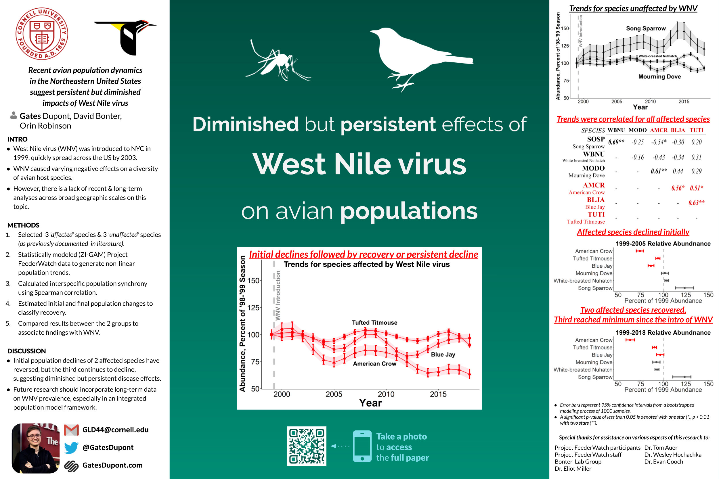
Recent avian population dynamics in the Northeastern United States suggest persistent but diminished impacts of West Nile virus
Gates Dupont, David Bonter, Orin Robinson
Spring 2017 - Spring 2019
Abstract: Soon after its introduction to North America in 1999, West Nile virus spread rapidly across the continent and negatively impacted the populations of a diversity of avian host species. The potentially continuing effects of the introduction of the virus, however, have not been fully explored. To determine whether long-term population trends are correlated with the persistence of the virus in the study region, I analyzed 19 years of Project FeederWatch data from the Northeastern United States to generate population trends with a dynamic, multivariate, and temporal modeling approach. To associate the effects of West Nile virus with population trends, I generated estimates of relative abundance for a suite of six species chosen a priori. These species included three that experienced significant population declines due to the virus and three that have been considered to have unaffected populations. I confirmed the initial population decline in the three affected species and documented a partial and full recovery of two of the species by the end of study period. The remaining species, American Crow, had not yet recovered by 2018, with relative abundance estimates at 63% of pre-disease levels. There was also significant synchrony in the inter-annual population trends of the affected species.
Presentations: New York State Ornithological Assosciation 71st Annual Meeting - Rochester, NY 2018, American Ornithological Society 137th Meeting - Anchorage, AK 2019
Seabirds to Starboard: Notes on Norse Navigational Technique
Gates Dupont, Oren Falk
Fall 2015 - Spring 2018
Abstract: Pictorial cartography was, as far as we know, foreign to the Norsemen of the Viking Age and later Middle Ages; they were nevertheless capable of reliably navigating long distances, apparently by creating ‘narrative maps’ of their routes: verbal accounts of prominent land- and sea-marks, presumably passed down orally and eventually, occasionally, in written form. We have some examples in Ohthere’s and Wulfstan’s narratives (preserved in the Old English Orosius), as well as in Bjarni Herjólfsson’s account of his accidental discovery of America (in Grœnlendinga saga). The utility for navigators of prominent landmarks – headlands, high mountains, distinctive terrestrial formations, and so on – is self-evident, but reports of the less stable markers used to navigate over open waters are of particular interest. Already Alcuin in 793 ad acclaimed Norse mariners’ ability to cut across the North Sea as a hallmark of their fearsome ingenuity. Quite how they did it remains enigmatic to this day. One possible clue Norse navigators probably resorted to was observation of marine birdlife; a brief comment preserved in Landnámabók about the sighting of Icelandic birds en route to Greenland is suggestive of how such lore may have been packaged and transmitted as part of culturally resonant narratives. Around the North Atlantic, population pockets of related avian species have distinctive appearances and behaviours, which an informed observer could use to make educated localisation guesses (recognising, for instance, that birds sighted are ‘from Iceland’). Seasonal patterns and interaction within and among species could also provide important directional and proximity clues, and perhaps even hint at longitude and latitude. Finally, human manipulation of avian behaviour could help guide sailors (as Flóki Vilgerðarson is said to have demonstrated in maverick fashion on his discovery voyage to Iceland). This paper surveys some of the likely techniques available to the Norsemen for navigating by observation of pelagic fowl, and retrieves evidence for such practices from the surviving narrative records. The authors combine ornithological, historical, and narratological perspectives to analyse these data as pointing both at original cultural praxis – the knowledge that mariners would have valued and sought to manipulate – and at meaningful textual tropes, significant narrative elements that enabled preservation and transmission of such knowledge as a mode of recounting spatial experience.
Presentations: Time, Space & Narrative in Medieval Icelandic Literature - University of Reykjavik, Iceland 2017